Warnings across Yorkshire as 'mini Beast from the East' is set to make it a white weekend


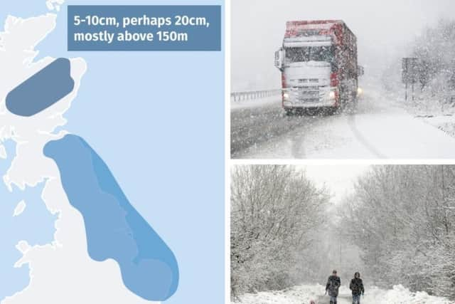
Up to 5cm (2in) of snow could fall in some parts of the country and up to 20cm (8in) on higher ground - prompting yellow snow and ice warnings to be issued for Saturday.
Advertisement
Hide AdAdvertisement
Hide AdMet Office meteorologist Mark Wilson said: "The best way to describe this is as a real return to wintry conditions.
"The last couple of days have been quite mild across parts of the UK - we got to around 16C yesterday in Wales - but by tomorrow all of us will be back to very cold weather.
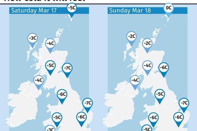
"Bitterly cold is the best way to describe it - temperatures on the face of it probably just around freezing but with wind it's going to feel well below freezing."
Advertisement
Hide AdAdvertisement
Hide AdThe Met Office website states: "A band of rain will increasingly turn to snow through late Friday afternoon and evening. As this band moves south-westwards, ice will also readily form on untreated roads, pavements and cycle paths.
"Some roads and railways are likely to be affected with longer journey times by road, bus and train services. Some injuries are also possible from slips and falls on icy surfaces.
"This warning has been updated to delay the start time until 1800 Friday and pull the area northwards into Angus, Perthshire and Aberdeenshire, mainly for icy conditions forming during the evening."
The Chief Forecaster's assessment adds: "Rain will increasingly turn to snow above around 200 metres during late Friday afternoon and evening.
Advertisement
Hide AdAdvertisement
Hide Ad"By the end of Friday evening, 2-5 cm of snow may accumulate on high ground above 200 metres.
"Some snow is likely even to low levels by late Friday evening with a very patchy 1-2 cm possible in places. There is some uncertainty in how quickly rain will turn to snow across the south of this area, with a small chance that these parts may only see rain starting to turn to snow during the early hours of Saturday."
The yellow warnings which stretch across the whole of Yorkshire on Friday, Saturday and Sunday have now been added to with the more serious amber warnings which stretch across the south of the county from 4pm Saturday through to 9am on Sunday.
Forecasters have updated to the amber warning as they expect the flurries to last longer, be more frequent and to be more intense from Saturday evening.
Advertisement
Hide AdAdvertisement
Hide Ad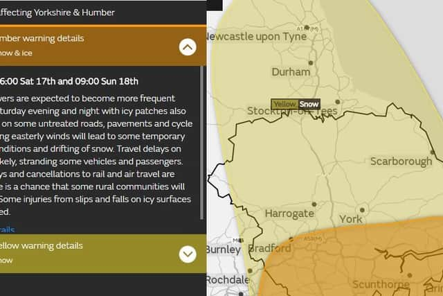
The cold weather should only last a few days though - by Tuesday temperatures will be getting back to average for the time of year.
Meteorologist Martin Bowles said the weekend's weather could be dubbed a "mini beast from the east".
He said: "We don't expect anything like the same impact as a result of it, although there will be some snow about."
Advertisement
Hide AdAdvertisement
Hide AdThe Met Office warnings for snow and ice begin at 6pm on Friday for eastern Scotland and England, and run into all of Saturday where London and the South East are included.
The snow warning for Sunday shows vast swathes of the south, central and east of England covered by the yellow advisory.
The warning states that travel disruption is possible, rural communities could become cut off, vehicles may be stranded and power cuts may occur.